El Cohete Soyuz Que Lanzará A La Astronauta Kate Rubins Y Los Cosmonautas Sergey Ryzhikov Y Sergey Kud-Sverchkov
El cohete Soyuz que lanzará a la astronauta Kate Rubins y los cosmonautas Sergey Ryzhikov y Sergey Kud-Sverchkov de la Expedición 64 a la estación el miércoles se prepara en plataforma de lanzamiento en Kazajstán.
Crédito: ISS
Más información: go.nasa.gov/2I1em2L


More Posts from Glaretum and Others

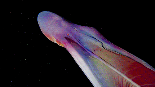
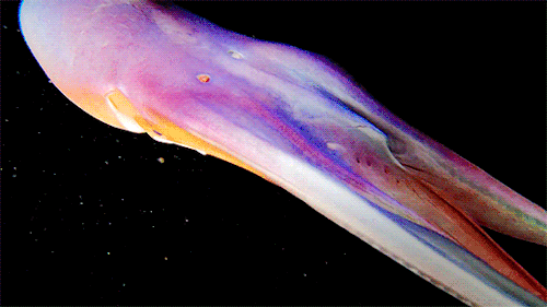
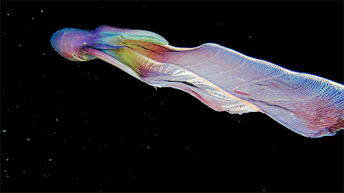
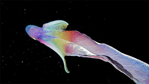
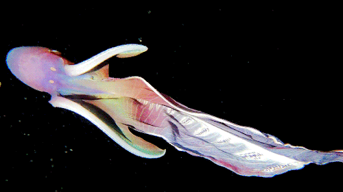
A close up of the Blanket Octopus during a blackwater dive with The Three P diving club , Romblon Island, Philippines. Credit: Joseph Elayani
Dreaming of going to space? – Astronaut Victor Glover has you covered.
In his first video from space, take a look at our home through the window of SpaceX’s Crew Dragon “Resilience” spacecraft. Victor arrived to the International Space Station alongside his fellow Crew-1 astronauts on Nov. 16, 2020.
This is his first trip to space and his first mission on the orbital lab!
Follow his Instagram account HERE to stay up-to-date on station life and for more behind-the-scenes content like this.
Make sure to follow us on Tumblr for your regular dose of space: http://nasa.tumblr.com.
Senda estelar alrededor del polo norte celeste. La estrella en el centro de los arcos celestiales concentricos es Polaris.
Imagen desde Bayanhaote, en el interior de Mongolia de China.
Crédito: Jeff Dai
https://instagram.com/jeffdaiphoto
~Antares

📸 Anthony Fuentes
Ig: https://instagram.com/fuentesphotocr
📍 Puntarenas, Costa Rica
~Félicette

Gemínida desde China
Crédito: Steed Yu

Rocket Launches and Rising Seas
At NASA, we’re not immune to effects of climate change. The seas are rising at NASA coastal centers – the direct result of warming global temperatures caused by human activity. Several of our centers and facilities were built near the coast, where there aren’t as many neighbors, as a safety precaution. But now the tides have turned and as sea levels rise, these facilities are at greater risk of flooding and storms.

Global sea level is increasing every year by 3.3 millimeters, or just over an eighth of an inch, and the rate of rise is speeding up over time. The centers within range of rising waters are taking various approaches to protect against future damage.

Kennedy Space Center in Florida is the home of historic launchpad 39A, where Apollo astronauts first lifted off for their journey to the Moon. The launchpad is expected to flood periodically from now on.

Like Kennedy, Wallops Flight Facility on Wallops Island, Virginia has its launchpads and buildings within a few hundred feet of the Atlantic Ocean. Both locations have resorted to replenishing the beaches with sand as a natural barrier to the sea.

Native vegetation is planted to help hold the sand in place, but it needs to be replenished every few years.

At the Langley Research Center in Hampton, Virginia, instead of building up the ground, we’re hardening buildings and moving operations to less flood-prone elevations. The center is bounded by two rivers and the Chesapeake Bay.
The effects of sea level rise extend far beyond flooding during high tides. Higher seas can drive larger and more intense storm surges – the waves of water brought by tropical storms.

In 2017, Hurricane Harvey brought flooding to the astronaut training facility at Johnson Space Center in Houston, Texas. Now we have installed flood resistant doors, increased water intake systems, and raised guard shacks to prevent interruptions to operations, which include astronaut training and mission control.

Our only facility that sits below sea level already is Michoud Assembly Facility in New Orleans. Onsite pumping systems protected the 43-acre building, which has housed Saturn rockets and the Space Launch System, from Hurricane Katrina. Since then, we’ve reinforced the pumping system so it can now handle double the water capacity.

Ames Research Center in Silicon Valley is going one step farther and gradually relocating farther south and to several feet higher in elevation to avoid the rising waters of the San Francisco Bay.
Understanding how fast and where seas will rise is crucial to adapting our lives to our changing planet.

We have a long-standing history of tracking sea level rise, through satellites like the TOPEX-Poseidon and the Jason series, working alongside partner agencies from the United States and other countries.

We just launched the Sentinel-6 Michael Freilich satellite—a U.S.-European partnership—which will use electromagnetic signals bouncing off Earth’s surface to make some of the most accurate measurements of sea levels to date.
Make sure to follow us on Tumblr for your regular dose of space: http://nasa.tumblr.com.
Lago Gallineta, Idaho, con las montañas Sawtooth en el fondo.
EXIF: Sony a7riii, lente Sony 24 mm f/ 1.4 GM
Sky-3 fotos en IS01600, 2 minutos en f / 2.0 (rastreado usando un sky adventurer tracking mount)
Foreground-3 fotos en IS01600, minutos en f / 1 .4
Reflexión de fondo-fotos en IS06400, 20 segundos en la f1.4.
Crédito: Bryony Richards & Eric Benedetti 🇺🇸🇬🇧
✨ Astrophotography of Utah & beyond ✨
https://www.utahastrophotography.com/
https://instagram.com/utahastrophotography
~Antares

Un árbol de siluetas desde la Bahía Barnegat, Jersey Shore, NJ.
Crédito: John Entwistle
https://instagram.com/johnentwistle_photography
~Antares

Vía Láctea desde Valley of Fire State Park.
Este es el parque estatal más antiguo en jurisdicción de Nevada, al oeste de Estados Unidos que fue designado como Monumento Nacional Natural en 1968.
Su nombre se deriva de las formaciones de arenisca rojas, los piedras arenisca "aztecas", que se formaron a partir de grandes dunas durante la era de los dinosaurios.
Crédito: Gary Cummins
https://instagram.com/garycphoto
~Antares


Glaretum fundado en el 2015 con el objetivo de divulgar la ciencia a través de la Astronomía hasta convertirnos en una fuente de conocimiento científico veraz siendo garantía de información seria y actualizada.
248 posts